Share this Post
This article may contain affiliate links. For full information, please see our disclosure here.
The Quiraing circuit on the Isle of Skye is one of the most picturesque hikes on the island, located on the Trotternish Loop. It can be reached by travelling on a single-track minor road from Staffin to Uig.
I had eagerly looked forward to hiking the Quiraing, having read about its unique rock formations and otherworldly landscape. Unfortunately, we had to postpone the hike several times over a period of five days due to bad weather conditions and low visibility caused by fog. However, on our last day, we braved the elements and embarked on the hike. Although it was only 7 km long, it felt like the most difficult and soul-destroying hike during our month-long road trip in Scotland.
Our guide to the Quiraing hike includes a picture guide, a detailed map as well as instructions on how to get there and complete the hike. I can only imagine how stunning the Quiraing landscape must look on a clear day, so we plan to return one day. Until then, I have some foggy pictures to share with you. 🙂
TABLE OF CONTENTS
1. About the Isle of Skye
2. About the Quiraing
3. Hiking Stats for the Quiraing Circuit
4. Getting to the Start of the Quiraing Circuit
5. The Outward Leg
6. The Return Leg
7. Camping on the Isle of Skye
8. Things to Do on the Isle of Skye
9. Resources
10. Hiking Gear for the Quiraing Circuit
11. Frequently Asked Questions
12. Final Words
1. About the Isle of Skye

The Isle of Skye is an island located off the North-West coast of Scotland. It is the largest of the Inner Hebrides, and is known for its stunning natural beauty, including rugged coastlines, rolling hills, and towering peaks.
Skye is also rich in history and culture, with ancient ruins, castles, and museums dotting the landscape. The island is home to a diverse array of wildlife, including rare birds, seals, and otters, and is a popular destination for outdoor activities such as hiking, fishing, and kayaking.
The Isle of Skye has become a popular tourist destination, attracting visitors from all over the World with its breathtaking scenery and rich cultural heritage. Despite its growing popularity, the island has managed to maintain its rugged and remote character, offering visitors a true taste of the Scottish wilderness.
2. About The Quiraing
The Quiraing is a stunning landscape formation located in the Trotternish peninsula on the Isle of Skye in Scotland. The area is renowned for its unique geological features, which were formed by a series of landslips and erosion over millions of years. The Quiraing is believed to be around 175 million years old, making it a significant historical landmark.
The Quiraing walk, a 7 km circuit, offers hikers an unforgettable experience of the spectacular scenery, including the jagged peaks of the Trotternish Ridge. Along the walk, you can also witness the mysterious rock formations known as The Table, The Needle, and The Prison. The walk takes around 3-4 hours, and there are several viewpoints along the way, offering breathtaking panoramic views of the surrounding countryside.
3. HIKING STATS FOR THE QUIRAING CIRCUIT
Starting Point: The Quiraing Car Park, Sartle, Staffin, Portree IV51 9LB, Scotland | Grid Ref: NG440679 | Open in Google Maps
Distance: 7.27 km
Elevation Gain: 371 m
Time: 3-4 hours
Difficulty: Strenuous
Ordnance Survey Map: OS Explorer 408
The Quiraing Map & GPX File: View Route Map & Download GPX File

Quiraing Circuit, Isle of Skye – Elevation Profile

OS Maps App: As a backup for a physical map and compass, I also utilise the Ordnance Survey Maps app, which I highly recommend. I find it very useful, especially when precise navigation isn’t always possible with kids in tow or due to low visibility. The app allows you to plan your routes, save them offline, and print them at scale, just to name a few features. You can sign up for the app by clicking the link below.
4. Getting to the Start of the Quiraing Hike

The Quiraing is situated on the Trotternish Loop on the Isle of Skye and can be reached by a single-track minor road from Staffin to Uig. To get to the start of the Quiraing walk, park at the Quiraing Car Park, Sartle, Staffin, Portree IV51 9LB, Scotland | Grid Ref: NG440679 | Open in Google Maps. There is a parking charge. The start of the Quiraing walk is sign-posted and starts across the road from the car park.
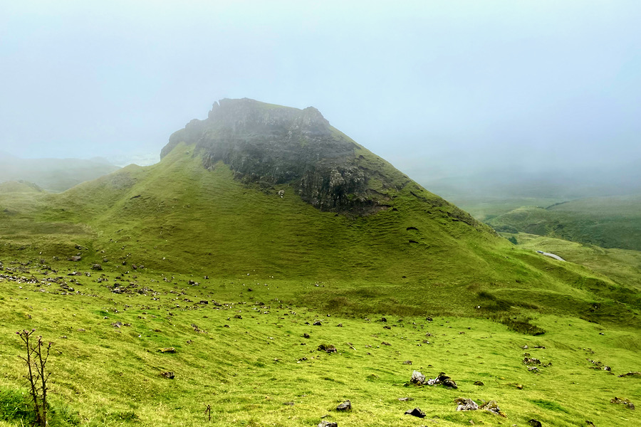
When I first peered out of our campervan at 8am, I was greeted by the views in the image below. At about 1pm, the three of us finally set off to attempt the Quiraing circuit, after having waited out the bad weather for as long as we could.

5. The Outward Leg
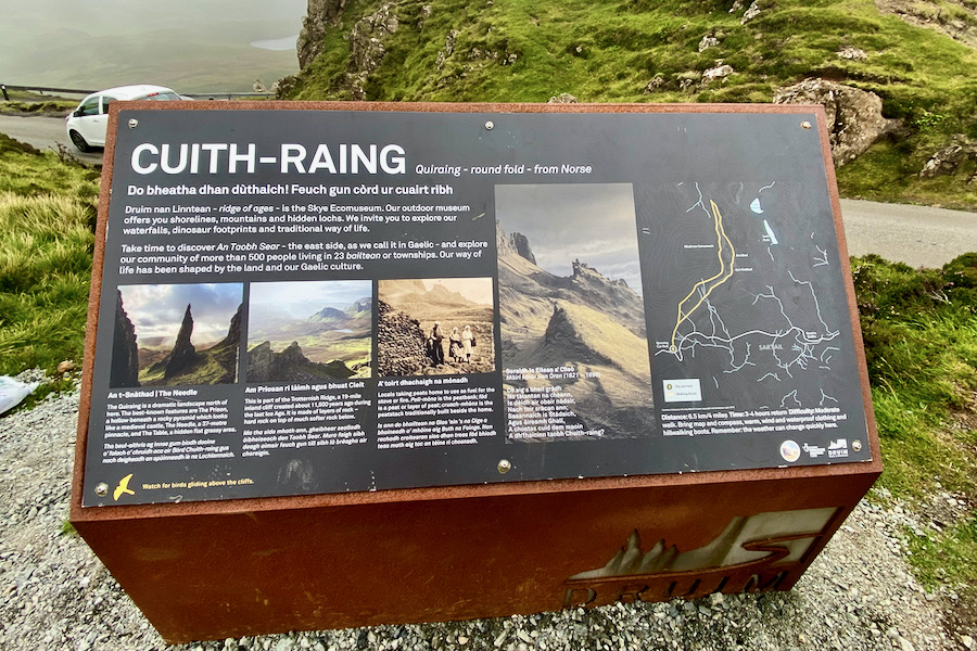
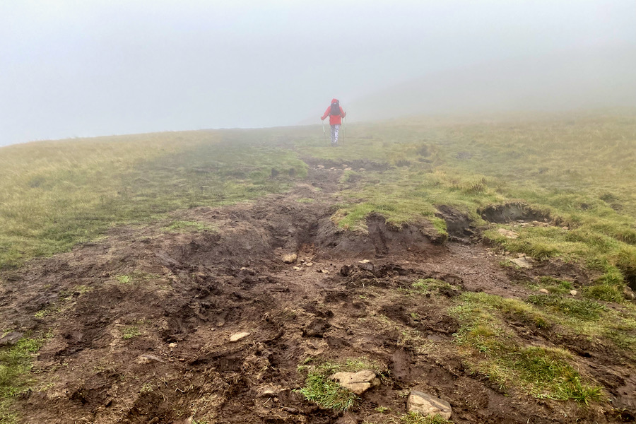
At the beginning of the hike, there is an information board about the Quiraing, which includes a map. Follow the gravel footpath, which will soon turn into a well-trodden earthy path that can become muddy when wet.

After about 100 metres, you will arrive at a fork. It doesn’t matter which path you take here as both paths will meet again after only 50-100 metres. We took the path to the right.


The path is narrow in places, so take great care when passing other hikers.

You will encounter several streams along the way that are always fun for kids to cross.

The image below shows the view up a ravine of one of the streams.

The view over the Quiraing opens up in front of you when you cross the next stream.

The lush green landscape of the Quiraing is stunning and almost otherworldly. I just wish we had had better weather to fully appreciate the breathtaking views.

As you continue on the path, you will cross yet another stream.

The image below shows the footpath from where we came.


According to the Ordnance Survey map, the route progresses towards The Needle. However, after approximately 1.3 km, which constitutes about one-third of the outward journey, we found ourselves heading towards The Prison instead, as I couldn’t locate the path leading to The Needle. It’s worth noting that this specific route isn’t illustrated on the Ordnance Survey Explorer map (1:25,000).
When I realised that we had taken the wrong path, we retraced our steps for a few hundred metres in an attempt to locate the fork that would lead us to the correct route. Unfortunately, I couldn’t make out that path, so we continued on the well-trodden footpath that we were on.
Even after examining the section of the route on Google Earth, which displayed the dotted footpath on the Ordnance Survey map that I had intended to follow, I still struggled to make out the path clearly. In conclusion, the path we ended up taking – which I call the lower path – was considerably easier to navigate than the upper path shown on the map.
Ultimately, it doesn’t really matter which path you take here because they merge after about 500 metres (if you take the upper path) or 700 metres (if you take the lower path). I suggest taking the path that is the safest and easiest for you to locate and follow.


If you take the lower path, you will arrive at a fence where you will need to walk up a short, steep hill. In wet conditions, the area can be very muddy and slippery, so walking or trekking poles would come in handy.

If you take the upper path, you will reach the stile where the lower and upper paths meet. Cross the stile to continue the walk. You are now approximately halfway through the outward leg or a quarter of the way through the entire hike. At this point, the path bends, changing direction from northeasterly to northerly.


6. The Return Leg
On a clear day, you’ll be rewarded with breathtaking views stretching all the way from the Quiraing to the coast. Unfortunately, on the day we hiked, the fog obstructed any views.
The turning point is also nearly the mid-point of the hike. Here, the path takes a sharp left and heads towards a southerly direction. You will still gain elevation for another kilometre before reaching a point from which you will only go downhill.
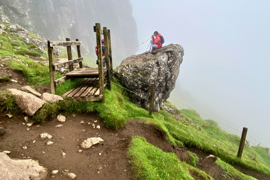
The return leg is a walk along the cliff, and some sections of the path are very narrow and close to the cliff edge. Therefore, it is crucial to take good care, especially in low visibility.
This spot is also a good place for a snack as the return leg can become very muddy and boggy when it’s wet, which was the case for us.

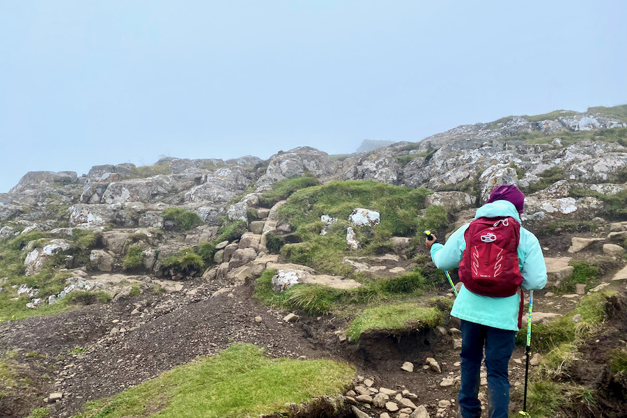
It was so foggy that we could hardly make out the cliff edge, as shown in the image below. If you’re hiking with kids in low visibility, keep them close. Normally, my kids hike ahead on safe trails, but on this occasion, I had to make sure I could see them at all times.

The majority of the return leg becomes very boggy when it’s wet – I ended up slipping and landing on my bottom twice.

Take care on sections of the path that are in close proximity to the cliff edge, especially in conditions of low visibility.

Navigation became quite challenging as we approached the peak of Meall na Suiramach in low visibility. The plateaued summit lacked any prominent features to orient ourselves with in such conditions.
We encountered other hikers who had strayed towards the Meall na Suiramach peak, likely due to the lack of visible footpaths.

When you reach the gate, cross it and continue following the footpath.


We were relieved when we finally made it back to the car park – wet, muddy, cold, wind-swept, exhausted, and mentally drained. However, we were also happy that we had embarked on the hike and even happier that we had returned safely. The first thing we did was indulge in a well-deserved hot chocolate – yum!

7. CAMPING ON THE ISLE OF SKYE
There are several Isle of Skye campsites to choose from. We decided to stay at the Uig Bay Campsite because of its convenient location for exploring the Trotternish Peninsula in the north-east of the island.
Although it’s a very basic campsite, it’s suitable for motorhomes or campervans. We needed an electric hook-up because the electrics in our hired campervan were causing problems, and we wanted to see if they could be fixed. It’s a practical campsite, but not an ideal spot for camping with a tent, so I wouldn’t recommend it for that purpose.
READ MORE: Camping Essentials: Complete Checklist for Camping with Kids
8. THINGS TO DO ON THE ISLE OF SKYE
- Hike the Old Man of Storr
- Walk to the Fairy Pools
- Explore the Fairy Glen
- Visit the Staffin Dinosaur Museum
- Visit the Skye Museum of Island Life
- Walk along Coral Beach
- Take a boat to Loch Coruisk
- Visit Kilt Rock & Mealt Falls
- Visit Lealt Falls
- Walk to Brother’s Point
- Visit Neist Point Lighthouse
- Visit Dunvegan Castle
- Climb in the Cuillin Mountains
9. RESOURCES
When planning our 4-week road trip through Scotland, I drew inspiration from several travel guides to help me plan our itinerary and choose the best hikes and activities. These guides included Scotland The Best, Rough Guide, Cicerone, Bradt, and Wild guide books. I particularly like the structure and information provided in these guides, and they were instrumental in helping me plan our trip.
If you’re planning a trip to Scotland and want to explore the beautiful countryside and hike the stunning mountains, check out these guide books. They are a great resource and will help you plan the perfect itinerary for your trip.
TRAVEL & WALKING GUIDES AND MAP FOR THE OLD MAN OF STORR
- Scotland The Best
- The Rough Guide to Scottish Highlands & Islands
- The Isle of Skye: Graded walks and scrambles throughout Skye, including the Cuillin
- Ordnance Survey Map: OS Explorer 408
10. HIKING GEAR FOR THE QUIRAING CIRCUIT
To have the best chance of a safe and successful hike, it’s vital that you’re well-prepared and well-equipped. This is true for both yourself and your kids. Do not cut corners when it comes to kitting out your kids with appropriate hiking gear, too.
Well-fitting, water-proof hiking boots with ankle support, as well as hiking socks for comfort, make up the basis for essential hiking gear. In addition to these items, it’s also important to pack the following items for a day hike:
ESSENTIAL HIKING GEAR LIST
For Adults
- Rucksack (Women’s / Men’s)
- Dry bag
- Water bladder or water bottle
- Emergency Shelter
- Trekking or Nordic Walking poles
- Head torch
- Whistle
- Mini First Aid Kit
- Map (& Compass, if you know how to use it)
- Sun Cream
- Mobile Phone
- Camera
- Nutritious snacks
For Kids
- Rucksack
- Dry bag
- Water bladder or water bottle
- Trekking or Nordic Walking poles
- Head torch
- Whistle
- Nutritious snacks
ESSENTIAL HIKING CLOTHING
For Adults
Hiking boots with ankle support
- Hiking Socks
- Hiking trousers
- Rain jacket & rain trousers
- Spare mid layer
- Sun hat
For Kids
- Hiking boots with ankle support
- Hiking Socks
- Hiking trousers
- Rain jacket & fleece layer
- Rain trousers
- Sun hat
By packing these essential items, you’ll be well-prepared for your hike and have the best chance of a safe and successful trip.
11. FREQUENTLY ASKED QUESTIONS
How long does it take to hike the Quiraing?
The time required to hike to the Quiraing can vary depending on several factors, such as your fitness level, the weather conditions, and the number of breaks you take. On average, completing the Quiraing circuit hike takes between 3-4 hours.
What’s the elevation gain for the Quiraing hike?
The elevation gain for the Quiraing hike is about 371 metres.
Parking for the Quiraing?
The Quiraing Car Park, Sartle, Staffin, Portree IV51 9LB, Scotland | Grid Ref: NG440679 | Open in Google Maps
What is the best time of year to hike the Quiraing?
In general, the hiking season in Scotland runs from April to October, and the driest and warmest weather typically occurs in the summer months of June to August. If you’re looking for the best weather and longest days, then hiking to the Quiraing in the summer might be the best option for you. However, keep in mind that the weather in Scotland, and especially on the Isle of Skye, can be unpredictable, so it’s important to be prepared for all conditions and plan accordingly.
Weather for the Quiraing?
When planning to hike the Quiraing, it’s important to check the weather forecast in advance, as the weather in the mountains can be unpredictable and change quickly. You can check the most up-to-date and accurate weather information by using the Mountain Weather Forecast on the MetOffice website or app.
During our five-day road trip on the Isle of Skye, we experienced extremely foggy weather and frequent showers, so it’s essential to be prepared for similar conditions.
Is the Quiraing hike dangerous?
The hike to the Quiraing can be challenging, especially in adverse weather conditions such as heavy rain, strong winds, and low visibility. There are also some sections of the path that are narrow and close to the cliff edge, so it’s crucial to take care and be cautious, especially in low visibility. However, as long as you are well-prepared and take the necessary precautions, such as wearing appropriate clothing and footwear, carrying enough water and food, and checking the weather forecast beforehand, the hike can be done safely. It’s always advisable to use your best judgment and assess the conditions before attempting any hike.
Would I recommend hiking the Quiraing with kids in tow?
Hiking the Quiraing with kids is possible, but it largely depends on the age and experience level of the children, as well as the weather conditions on the day of the hike. The trail can be challenging and potentially dangerous in certain sections, particularly when it’s wet or foggy. It’s important to keep a close eye on your children and ensure they stay on safe paths, away from cliff edges. My children were 9 and 12 years old when we did this hike.
How to get to the Quiraing?
To get to the Quiraing, take the single-track minor road from Staffin to Uig located on the Trotternish Loop on the Isle of Skye.
12. Final Words
Hiking the Quiraing was at the top of our wish list during our 5-day stay on the Isle of Skye. Due to unfavorable weather conditions, we had to postpone the hike several times until the final day. However, I’m glad we finally gave it a go and managed to complete the entire circuit, but my goodness, it was the most arduous hike we have encountered thus far.
The foggy, windy, and wet conditions were not ideal for hiking. In hindsight, it may not have been the safest option either, especially during the cliff walk back to the starting point. The poor visibility was a major concern, and I had to keep my kids close-by as some sections of the path were narrow and close to the cliff edge.
Fortunately, I had thoroughly studied the route and used the Ordnance Survey app as a backup. This made me feel safe and allowed me to navigate accurately. Without this tool, it would have been quite challenging to navigate the cliff walk as it was through grassland without any distinct footpath, resembling a plateau at times.
Overall, this is a hike we would love to do again in the future, especially in clear weather.
Happy Hiking!
Related Posts
- Old Man of Storr: The Isle of Skye’s Most Popular Hike
- Lost Valley, Glencoe: A Legendary Hike in the Scottish Highlands
- Beinn Eighe Mountain Trail: Britain’s Only Way-Marked Hike
- Stac Pollaidh Scotland: Our Attempt to Reach the True Summit
- The Cobbler Scotland with Kids: Your Complete Picture Guide + Map
- Best Hikes in Scotland: 12 Stunning Walks in the Highlands
- 10 Best Castles in Scotland to Visit
- Ben Nevis Mountain Track with Kids: The Ultimate Picture Guide
You Might Also Like
- Amphitheatre Buttress: A Classic Climb in North Wales
- Snowdon Watkin Path with Kids: The Ultimate Picture Guide
- Devil’s Kitchen Snowdonia with Kids: The Complete Picture Guide
- Top 20 Family Outdoor Activities in Wales
- Scafell Pike Corridor Route with Kids: The Ultimate Picture Guide
- 12 Epic Reasons to Solo Road Trip with Kids (and 5 Against)
- How to Plan a Europe Road Trip – The Essential Guide
- Top 11 Road Trip Activities for Kids
- Camping Essentials: Complete Checklist for Camping with Kids
- Climbing Cadair Idris via the Cyfrwy Arete: A Multi-Pitch Adventure
- The Ultimate Family Road Trip Packing List
Share this Post