Share this Post
This article may contain affiliate links. For full information, please see our disclosure here.
Hiking the Adolf-Munkel-Weg Trail
On Day 4 of the 5-Day Puez-Odle Altopiano hut-to-hut trek, you’ll traverse the entirety of the Adolf-Munkel-Weg trail from Rifugio Genova (Schlüterhütte) to Rifugio Malga Brogles (Brogleshütte). This hike predominantly winds through forests, featuring a notably steeper descent than ascent, which can be particularly demanding.
After the initial 1.5 hours of descent, the terrain briefly levels out before descending again, and finally, you’ll gradually ascend for the last 2 kilometres.
With just a 5-minute detour, you can explore a Kletterwald (translated from German as “climbing garden”), which features several boulders to climb. This spot is also perfect for a picnic lunch, where you can watch climbers attempting to scale the boulders.
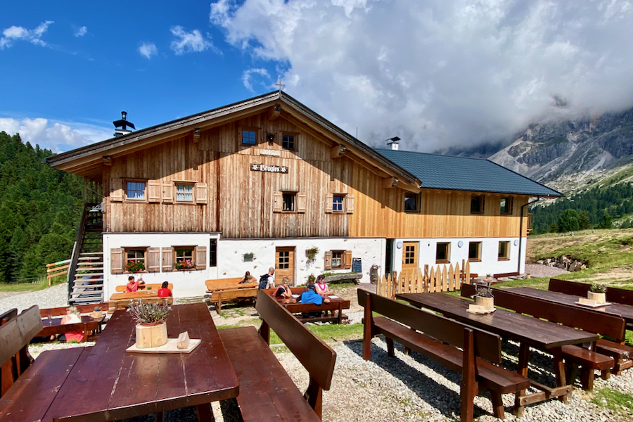
Rifugio Malga Brogles (Brogleshütte) is situated just behind the peaks of Seceda, which, from this angle, do not resemble it at all. This alpine hut has been extended and fully renovated in 2023 and boasts bright private rooms.
In this article, I provide a complete hiking guide of Day 4 of the 5-Day Puez-Odle (Puez-Geisler) Altopiano hut-to-hut hike, which we completed in a counter-clockwise direction; including hiking statistics, maps, and pictures.
For a comprehensive overview of the entire 5-Day hike, please refer to our article titled Puez-Odle Altopiano: A Multi-Day Hut-to-Hut Hike in the Dolomites.
About the Adolf-Munkel-Weg Trail
The Adolf-Munkel-Weg is a 9.5 km long trail nestled in Val di Funes (Villnöss), beneath the majestic Odle (Geisler) mountain range in the Dolomites. Serving as a point-to-point route, it connects Rifugio Genova (Schlüterhütte) to Rifugio Malga Brogles (Brogleshütte).
For three decades, Adolf Munkel served as the founder and section chairman of the Dresden Alpine Club. In 1905, the Dresden Alpine Club’s dedication led to the establishment of the well-loved hiking trail at the base of the Odle (Geisler) peaks. This path was aptly named in tribute to the esteemed contributions of its founder, Adolf Munkel.
While many opt to hike only a portion of the trail from Zannes/Zans, transforming it into a loop, we embarked on the entire Adolf-Munkel trail from Rifugio Genova to Rifugio Brogles. This trail can also be hiked in the opposite direction.
Adolf-Munkel-Weg Trail Hiking Stats
Start: Rifugio Genova (Schlüterhütte)
Finish: Rifugio Malga Brogles (Brogleshütte)
Distance: 11.80 km
Moving Time: 3 h 25 min
Elapsed Time: 5 h 25 min
Ascent: 410 m
Descent: 600 m
Difficulty: Moderate
Minimum Elevation: 1872 m
Maximum Elevation: 2478 m
Map: Tabacco 05 – Val Gardena – Alpe di Siusi / Groden – Seiseralm


Elevation Profile: Adolf-Munkel-Weg Trail

READ MORE: Puez-Odle Altopiano: A Multi-Day Hut-to-Hut Hike in the Dolomites
Adolf-Munkel Trail Hiking Guide
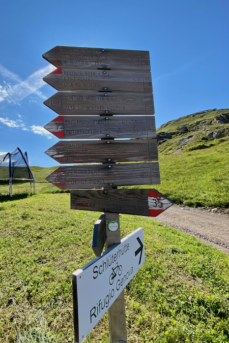
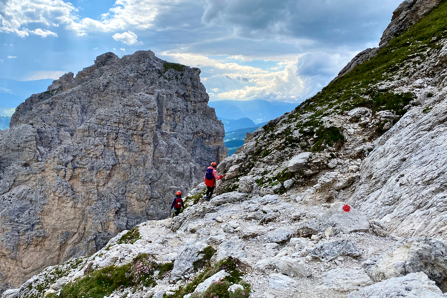
After stepping out of Rifugio Genova, turn right and follow path no. 35/36 downhill. This route goes in the opposite direction from the path you took yesterday to Sass de Putia (Peitlerkofel).
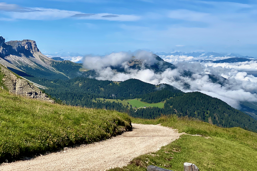
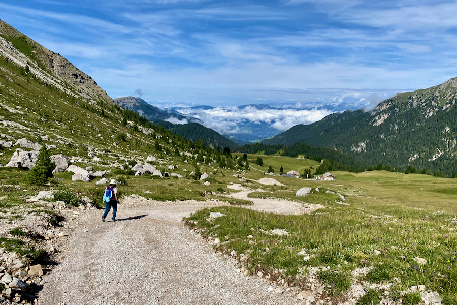
A wide gravel path immediately descends and continues downhill for the first 3.5 kilometres.
We were fortunate with the weather, especially with the sunny skies, but also because we found ourselves walking above the clouds, which lent a mystical atmosphere to the hike.
Interestingly, I found that walking downhill was tougher than walking uphill. Not because of knee strain, but because of the strain on my toes. My big toes felt sore for days afterwards, as they bore much of the pressure. It’s a weird feeling when you can never fully relax your muscles, constantly needing to brake on the descent. The kids, on the other hand, were totally fine. Sometimes they even ran downhill.
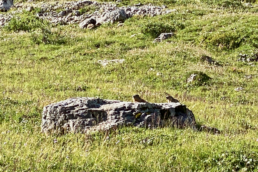
We were delighted to spot some marmots, a familiar sight for us, especially my youngest, who has a knack for discovering them. He was also the first to spot them during our trip to Austria a few years ago. Although the image below isn’t sharp due to the zoom, you can clearly make out the two marmots peeking over the rock.
Another, albeit less wild, yet equally adorable creature made an appearance as well.

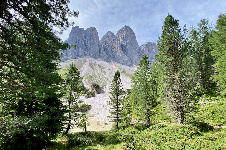
Approaching the Odle (Geisler) peaks serves as a reminder of the stunning beauty of this region of the Dolomites. From this point onward, you’ll be making your way through the forest until you reach Rifugio Malga Brogles (Brogleshütte/Broglesalm).

At the junction, take path no. 35 to the right. From here, it’s officially about a two-hour hike to Rifugio Malga Brogles (Brogleshütte). We took longer though, as we enjoyed the leisurely hike and took a long break for lunch.
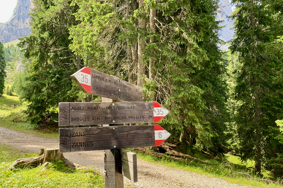
After crossing the Rio San Zenone stream, continue on path no. 35 to the left.


About 4.5 km into the hike, keep an eye out to your left where a small path emerges from the forest onto scree. Look for a sign labeled “Kletterwald” (translated from German as “climbing garden”), indicating several boulders for climbing. This spot is also ideal for a picnic lunch, where you can enjoy watching climbers attempting to scale the boulders.
Even without climbing gear, you can still scale the boulders using easy scrambling routes. The kids loved scrambling here and watching other hikers attempt the walls, although many didn’t get far as they didn’t have the necessary gear for the harder routes.


You can spot the Adolf-Munkel-Weg plaque along the way.

After visiting the Klettergarten (climbing garden in German), there are two ways to return to the hiking path. The quickest and safest option is to retrace your steps.
However, we decided to tag along with some temporary hiking buddies and followed them past the boulders and through some bushes until we eventually found our way back to the path, somehow!

Continue on path no. 35 that leads all the way to Rifugio Malga Brogles.

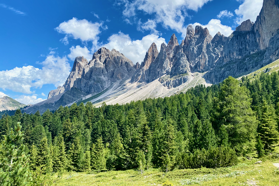
You’ll trace the imposing Odle (Geisler) peaks all the way to Rifugio Malga Brogles.

At the fork, continue on path no. 35.

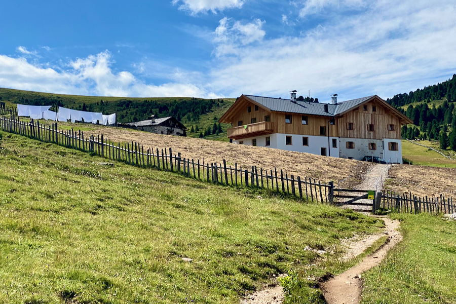
The last stretch of the hike leads out of the forest, around an outcrop, and onto pasture before finally arriving at Rifugio Malga Brogles (Brogleshütte).


Looking back to the Adolf-Munkel-Weg trail from where we came.

Rifugio Malga Brogles (Brogleshütte) is a welcoming sight after a day of hiking. It almost seems to appear out of nowhere the moment you emerge from the forest.
The view towards Forcella Pana (Panascharte), a scree field leading to a col, which we were set to ascend the next day. Unbeknownst to us until later that evening, the scree field was actually closed due to rockfall. Consequently, our plans for the following day had to be amended accordingly.

A majestic rainbow arched over the even more majestic Odle (Geisler) peaks in the evening.

Facilities at Rifugio Malga Brogles
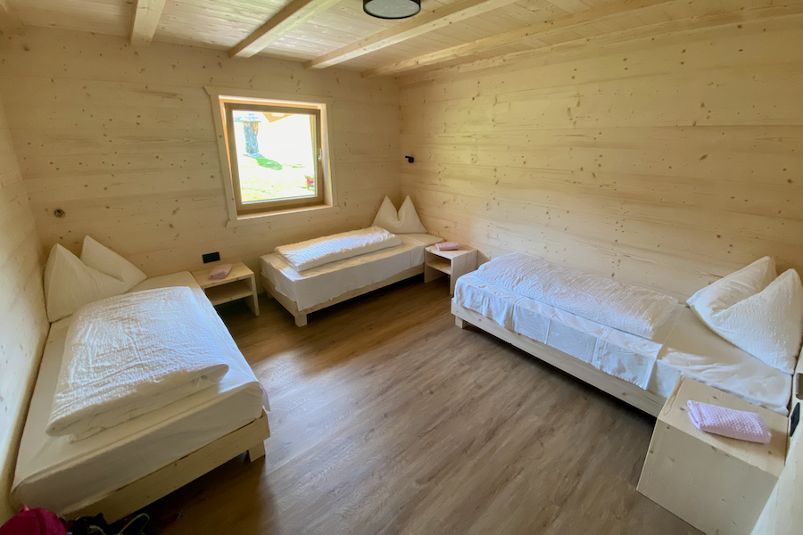
Rifugio Malga Brogles (Brogleshütte) offers only private rooms. This cozy 3-bed room was the most comfortable of the three mountain huts we stayed at, primarily because we didn’t need to use a sleeping bag liner, allowing us to truly stretch out.
The spacious and newly refurbished ladies’ bathroom consists of a shower cubicle and a toilet cubicle. The shower cubicle is enclosed in glass, so one of us stood guard while the other showered. It’s a peculiar set-up, and I should have asked why.
Dinner Options at Rifugio Malga Brogles
Rifugio Malga Brogles (Brogleshütte) offers à la carte options for dinner, catering to both vegetarians and non-vegetarians. While there weren’t many options to choose from – we were definitely spoiled at Rifugio Genova (Schlüterhütte) the past two nights – the portion sizes were generous, and the food was delicious.
Overview of the 5-Day Puez-Odle Altopiano Hike
Day 1: Vallunga (Langental) to Rifugio Puez (Puez Hütte)
Day 2: Rifugio Puez (Puez Hütte) to Rifugio Genova (Schlüterhütte)
Day 3: Rifugio Genova (Schlüterhütte) to Sass de Putia (Peitlerkofel) and back
Day 4: Rifugio Genova (Schlüterhütte) to Rifugio Malga Brogles via the Adolf-Munkel-Weg trail
Day 5: Rifugio Malga Brogles (Brogleshütte) to Vallunga (Langental)
What do Alpine Huts Provide?
- Accommodation: Most mountain huts offer dormitory-style sleeping arrangements with bunk beds or single beds. Some also provide private rooms for couples or small groups.
- Meals: Meals are typically available, including breakfast, lunch and dinner, often featuring hearty mountain cuisine. Packed lunches for day hikes can often be arranged.
- Beverages: Huts serve a variety of beverages, including hot and cold drinks, soft drinks, and alcoholic ones.
- Shower and Toilet Facilities: Huts have bathroom facilities, including showers and toilets. Typically, there is an additional fee for hot showers.
- Blankets and Bedding: Mountain huts typically provide duvets/blankets and pillows, eliminating the need for you to carry your own sleeping bag. However, you will need to bring your own sleeping bag liner/travel sheet. I have a cotton sleeping bag liner while the kids have a super-light silk sleeping bag liner.
- Electricity and Charging: Some huts offer electricity for charging devices like phones and cameras, but it’s not a guarantee. Be prepared with portable chargers if needed.
- Resupplying Essentials: You can often purchase basic necessities like snacks, drinks, and toiletries at mountain huts. Prices are higher due to the remote locations.
- Information: Hut staff can provide information about the trail conditions, weather forecasts, and hiking routes in the area.
Packing List for Hut to Hut Hiking in the Dolomites
Surprisingly, you don’t need to pack as much as you might think for a multi-day hike in the Dolomites. You can purchase all the food in the mountain huts, including a packed lunch. I carried a 30L day pack, while my kids each had an 11L day pack.
Pack one set of evening clothes for use in the mountain huts, a spare set of hiking clothes (consider adding extra t-shirts if you prefer), a spare pair of hiking socks, the bare minimum of underwear that you can manage with comfortably, rain gear, pyjamas, a sleeping bag liner, water-proof slippers to wear inside the mountain huts (as hiking boots are not allowed in the dorms), essential toiletries, and a micro-fibre travel towel. The most important items to aid your sleep will be a pair of ear plugs and an eye mask.
Additionally, include trekking or walking poles, a first aid kit with necessary medications, a sun hat, a buff or warm hat, gloves, a water bladder or water bottle, high-altitude sunglasses, a head torch,a map, a compass, and a dry bag.
Pro Tip: A set of thin thermals make for great light-weight and warm pyjamas.
Resources
I planned our multi-day hut-to-hut hike around the Puez-Odle (Puez-Geisler) Altopiano with the help of Cicerone’s guidebook, “Walking in the Dolomites: 25 Multi Day Routes in Italy’s Dolomites”. Other guidebooks that inspired our 3.5-week road trip to the Dolomites included those from Rough Guide and Lonely Planet. For day hikes and Via Ferrata, I used the following guides:
- Cicerone: Shorter Walks in the Dolomites: 50 varied Day Walks in the Mountains
- Cicerone: Day Walks in the Dolomites: 50 short walks and all-day hikes in the Italian Dolomites
- Cicerone: Via Ferratas of the Italian Dolomites Vol 1: 75 routes – north, central and east ranges
FAQs
How long does the Adolf-Munkel-Weg trail hike take?
The Adolf-Munkel-Weg trail hike is officially estimated to take approximately 4 hours. However, it took us almost 5.5 hours to complete it, as we enjoyed a leisurely lunch break and some scrambling at the Klettergarten (climbing garden) along the way.
How challenging is the Adolf-Munkel-Weg trail hike?
The hike from Rifugio Genova to Rifugio Malga Brogles (Brogleshütte) is rated as a 2 in the Cicerone guidebook, with 1 indicating an easy hike and 3 representing a challenging one. We found this rating to be accurate, as the hike is of moderate difficulty. The main challenges of this hike are the sustained downhill sections, which I personally found more difficult than ascending. Specifically, it put strain on my big toes, though my knees were fine.
Do you need a guide for the Adolf-Munkel-Weg trail hike?
No, a guide is not necessary for the Adolf-Munkel-Weg hike. You can undertake it as a self-guided hike with minimal navigation skills, as the paths are well-marked and easy to follow.
Can you undertake the Adolf-Munkel-Weg trail hike with kids in tow?
You can certainly undertake the Adolf-Munkel-Weg trail hike with children. In fact, this is the easiest stage of the entire 5-day Puez-Odle Altopiano hike. My kids were 13 and 10 years old when we did this hike in the summer of 2023.
When is the best time to hike the Adolf-Munkel-Weg trail?
The best time to hike the Adolf-Munkel-Weg trail is usually from mid-June to late September/early October. That’s when the paths are usually snow-free and the mountain huts are up and running. Just keep in mind that each hut has its own opening and closing times, so it’s a good idea to check them individually.
How do you make reservations for the Rifugio Malga Brogles (Broglesalm) alpine hut?
Reservations for the Rifugio Malga Brogles alpine hut can be made either via a phone call or by contacting them via their Facebook page.
Final Words
On the fourth day of our 5-day hut-to-hut hike around the Puez Odle Altopiano, we encountered the easiest stage of the trek. The peaceful stroll through the forest provided a refreshing change from the rugged terrain of previous days. Despite the challenge of a sustained downhill trek that left my toes sore for days, we really enjoyed the hike.
Highlights of the day included delightful encounters with marmots, exploring the Klettergarten (climbing garden), and the awe-inspiring presence of the majestic Odle (Geisler) peaks watching over us throughout the hike.
Happy Hiking!
RELATED POSTS
- Puez-Odle Altopiano: A Multi-Day Hut-to-Hut Hike in the Dolomites

- Puez-Odle Altopiano Hike | Day 1: Vallunga to Rifugio Puez, Dolomites

- Puez-Odle Altopiano Hike | Day 2: Rifugio Puez to Rifugio Genova, Dolomites

- Puez-Odle Altopiano Hike | Day 3: Sass de Putia (Peitlerkofel), Dolomites

- Puez-Odle Altopiano Hike | Day 4: Adolf-Munkel-Weg Trail, Dolomites
- Puez-Odle Altopiano Hike | Day 5: Rifugio Brogles to Vallunga via Seceda, Dolomites
- 7 Best Via Ferratas in the Italian Dolomites (with Adventurous Kids)
- Complete Picture Guide to the Pitla Cir Via Ferrata, Dolomites

- Gran Cir Via Ferrata, Dolomites: Ultimate Picture Guide + Map
YOU MIGHT ALSO LIKE
- The Ultimate Family Road Trip Packing List
- 12 Epic Reasons to Solo Road Trip with Kids (and 5 Against)
- Top 20 Family Outdoor Activities in Wales
- Camping Essentials: Complete Checklist for Camping with Kids
- Snowdon Watkin Path with Kids: The Ultimate Picture Guide
Share this Post