
Share this Post
This article may contain affiliate links. For full information, please see our disclosure here.
The Puez-Odle Altopiano (Puez-Geisler Hochplateau in German) hut-to-hut hike covers a distance of 60 kilometres over 5 days. It involves a total ascent of approximately 3,000 metres and a descent of around 3,700 metres. This circular multi-day hike falls into the moderate to strenuous category, with the most demanding section encountered on Day 2.
According to the Cicerone guidebook, the Puez-Odle Altopiano hike is typically a 4-day trek, but it offers the option to include the ascent of Sass de Putia (Peitlerkofel) on either Day 2 or Day 3. Opting for this additional challenge extended our hike to five days.
In this article, I provide a summary of the entire 5-day Puez-Odle (Puez-Geisler) Altopiano hut-to-hut hike in a counter-clockwise direction, complete with hiking statistics, maps, and pictures for each day. I will delve deeper into each individual hiking day in future articles.
SAFETY NOTICE: In late July 2023, the route via Forcella Pana (Panascharte), from Malga Brogles to Seceda, was closed due to rockfall. To confirm its current status, please refer to local sources. As a result of this unexpected closure, we had to alter our Day 5 itinerary. I received notice of the closure the night before, but successfully adapted the route based on advice from Malga Brogles (Brogleshütte) alpine hut staff and fellow hikers. This adjustment involved taking a cable car ride and extending the route by around 10 kilometres.
Hiking Stats for the Puez-Odle Altopiano Hike
Start/Finish: Selva di Val Gardena (Wolkenstein)
Distance: 60 km
Walking Time: 5 days
Total Ascent: 3,000 m
Total Descent: 3,700 m
Difficulty: Moderate – Strenuous
Minimum Elevation: 1619 m
Maximum Elevation: 2875 m
Map: Tabacco 05 – Val Gardena – Alpe di Siusi / Groden – Seiseralm


Puez-Odle (Puez-Geisler) Hut-to-Hut Hike – Elevation Profile

Overview of the Puez-Odle Altopiano Hike
Day 1: Vallunga (Langental) to Rifugio Puez (Puez Hütte)
Day 2: Rifugio Puez (Puez Hütte) to Rifugio Genova (Schlüterhütte)
Day 3: Rifugio Genova (Schlüterhütte) to Sass de Putia (Peitlerkofel) and back
Day 4: Rifugio Genova (Schlüterhütte) to Rifugio Malga Brogles (Brogleshütte)
Day 5: Rifugio Malga Brogles (Brogleshütte) to Vallunga (Langental)
About the Puez-Odle Nature Park
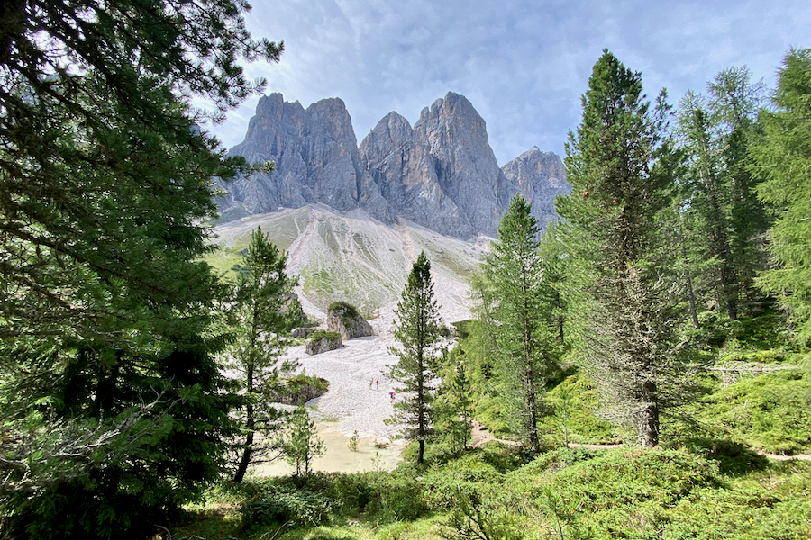
The Puez-Odle Nature Park (Puez-Geisler Naturpark), a protected area spanning 7,930 hectares within the Province of Bolzano, is nestled in the stunning landscapes of northeastern Italy’s South Tyrol region. It is comprised of a relatively compact mountain range, enclosed by three charming valleys: Val di Funes to the north, Val Badia to the east, and Val Gardena to the south. With its spiky peaks and lush meadows, it teems with flora and fauna.
The Puez-Odle (Puez-Geisler) Nature Park is part of the UNESCO-listed Dolomites, a renowned mountain range in the northern Italian Alps. The Dolomites, covering an expanse of approximately 141,903 hectares, are known for their rugged mountain terrain, characterised by towering vertical walls, steep cliffs, and an intricate network of narrow, deep valleys.
Day 1: Vallunga to Rifugio Puez

Vallunga (Langental) to Rifugio Puez (Puez Hütte) Hiking Stats
Start: Vallunga Car Park in Selva di Val Gardena (Wolkenstein)
Finish: Rifugio Puez (Puez Hütte)
Distance: 8.30 km
Moving Time: 2 h 30 min
Elapsed Time: 3 h 50 min
Ascent: 870 m
Descent: 0 m
Difficulty: Moderately Strenuous
Minimum Elevation: 1619 m
Maximum Elevation: 2475 m
Map: Tabacco 05 – Val Gardena – Alpe di Siusi / Groden – Seiseralm
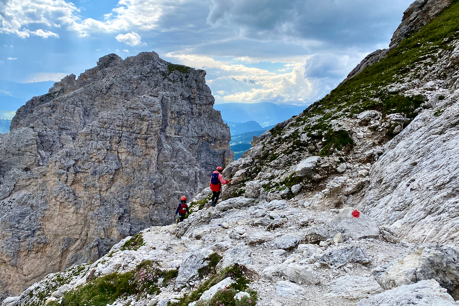
The first half of today’s hike leads you through the stunning Vallunga (Langental) before transitioning into steeper and rockier terrain. The ascent continues until you arrive at your overnight destination, Rifugio Puez (Puez Hütte). This remote hut is accessible solely by foot or helicopter, making it the most isolated stop on this 5-day hike.
Rifugio Puez offers three options of a 4-course set menu for dinner, accommodating both vegetarians and non-vegetarians. Although we were satisfied after devouring our delicious 4-course non-vegetarian meal, we couldn’t help but notice that the portions were small, highlighting the fact that everything delivered to the hut is transported by helicopter.


READ MORE: Puez-Odle Altopiano Hike | Day 1: Vallunga to Rifugio Puez
Day 2: Rifugio Puez to Rifugio Genova

Rifugio Puez to Rifugio Genova Hiking Stats
Start: Rifugio Puez (Puez Hütte)
Finish: Rifugio Genova (Schlüterhütte)
Distance: 13.25 km
Moving Time: 4 h 30 min
Elapsed Time: 7 h 45 min
Ascent: 710 m
Descent: 820 m
Difficulty: Strenuous
Minimum Elevation: 2187 m
Maximum Elevation: 2612 m
Map: Tabacco 05 – Val Gardena – Alpe di Siusi / Groden – Seiseralm
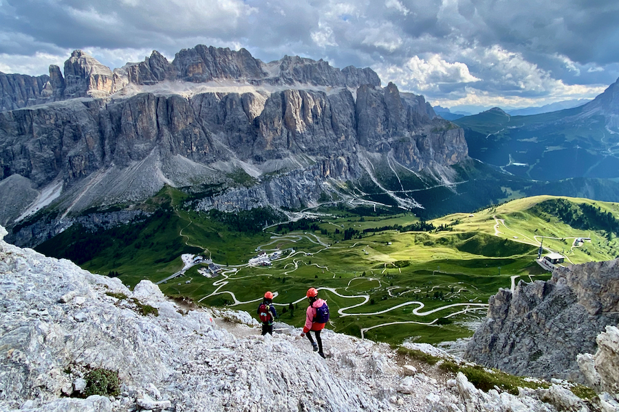
Day 2 of the Puez-Odle (Puez-Geisler) Altopiano hike marks the most extensive and challenging section. We underestimated the time needed to complete it, as the Cicerone guidebook indicated a duration of 4 hours. We set off at a leisurely pace, only to realise that the descent of the steep scree field at Forcella della Roa (Roascharte) required extreme caution, and the subsequent approach to Rifugio Genova (Schlüterhütte) took more time than anticipated.
The last 3 kilometres of the hike seemed almost endless. Rifugio Genova (Schlüterhütte) only came into view about 3 minutes before our arrival, tucked away behind a hill whose contour we were tracing. Fortunately, the à la carte dinner at Rifugio Genova (Schlüterhütte) more than made up for the demanding hike.
This segment of the multi-day hike is also part of the Alta Via 2 route – a 13-stage, 100-kilometre long-distance trail from Bressanone (Brixen) to Croce d’Aune, near Feltre, typically hiked in the opposite direction.


READ MORE: Puez-Odle Altopiano Hike | Day 2: Rifugio Puez to Rifugio Genova
Day 3: Rifugio Genova to Sass de Putia and back

Rifugio Puez to Sass de Putia Hiking Stats
Start/Finish: Rifugio Genova (Schlüterhütte)
Distance: 9.05 km
Moving Time: 2 h 50 min
Elapsed Time: 5 h 45 min
Ascent: 725 m
Descent: 725 m
Difficulty: Moderately Strenuous – Strenuous
Minimum Elevation: 2300 m
Maximum Elevation: 2875 m
Map: Tabacco 05 – Val Gardena – Alpe di Siusi / Groden – Seiseralm
Unless you are an extremely fit hiker, I recommend adding an extra day to hike to Sass de Putia (Peitlerkofel) as we did. This way, you can savour the hike, tackle the easy via ferrata to the true summit, and enjoy the views without feeling rushed.
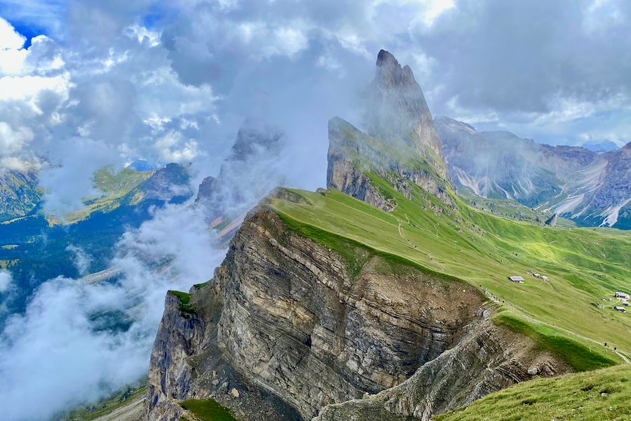
Standing tall at 2,875 metres above sea level (asl), you are rewarded with stunning 360-degree views across the Dolomites.
To reach the true summit of Sass de Putia (Peitlerkofel), you will need to ascend a grade 1 (easy) via ferrata. You won’t require via ferrata gear as long as you are sure-footed and comfortable with heights. Alternatively, you can hike to its secondary summit, which is only a few metres lower, without the need to climb the via ferrata.
Lacking via ferrata gear, I initially had concerns, but after consulting a couple of experienced climbers who were there with their grandchildren, I felt reassured that gear wasn’t a necessity. I also made it clear to the kids that we would turn back if the situation became too risky. Fortunately, we fared quite well, and we found the route neither too challenging nor hazardous.

Can you spot the hikers in the picture below?


READ MORE: Puez-Odle Altopiano Hike | Day 3: Sass de Putia (Peitlerkofel)
Day 4: Rifugio Genova to Rifugio Malga Brogles

Rifugio Genova to Rifugio Malga Brogles Hiking Stats
Start: Rifugio Genova (Schlüterhütte)
Finish: Rifugio Malga Brogles (Brogleshütte)
Distance: 11.80 km
Moving Time: 3 h 25 min
Elapsed Time: 5 h 25 min
Ascent: 410 m
Descent: 600 m
Minimum Elevation: 1872 m
Maximum Elevation: 2285 m
Map: Tabacco 05 – Val Gardena – Alpe di Siusi / Groden – Seiseralm
Today’s hike involves a much steeper descent than ascent, which can be challenging. You’ll be following the Adolf-Munkel-Weg trail, navigating diverse terrain, primarily through forests. After the initial 1.5 hours of descent, the terrain briefly levels out before descending again, and finally, you’ll gradually ascend for the last 2 kilometres.
With just a 5-minute detour, you can explore a Kletterwald (translated from German as “climbing garden”), which features several boulders to climb. This spot is also perfect for a picnic lunch, where you can watch climbers attempting to scale the boulders.
Malga Brogles (Brogleshütte) is situated just behind the peaks of Seceda, which, from this angle, do not resemble it at all. This alpine hut has been extended and fully renovated in 2023 and boasts bright private rooms.


READ MORE: Puez-Odle Altopiano Hike | Day 4: Adolf-Munkel-Weg Trail, Dolomites
Day 5: Rifugio Malga Brogles to Vallunga

Rifugio Malga Brogles to Vallunga Hiking Stats
Start: Rifugio Malga Brogles (Brogleshütte)
Finish: Vallunga (Langental)
Distance: 17.60 km
Moving Time: 3 h 25 min
Elapsed Time: 5 h 25 min
Ascent: 350 m (+ 700 m by cable car)
Descent: 1,600 m
Minimum Elevation: 1619 m
Maximum Elevation: 2478 m
Map: Tabacco 05 – Val Gardena – Alpe di Siusi / Groden – Seiseralm
As mentioned at the beginning of this article, we had to amend our route on Day 5 due to the closure of Forcella Pana (Panascharte), a scree field leading to a col, caused by rockfall. To confirm its current status, please refer to local sources.
If it remains closed, follow the instructions and route provided in this article. If it has reopened, you can proceed to ascend Forcella Pana (Panascharte), which will then lead you to Seceda. From there, continue the remainder of the hike through Rifugio Firenze (Regensburger Hütte) and ultimately return to Vallunga (Langental).
Consequently, the detour around the Geisler peaks leads you to the Furnes cable car station, functioning as the intermediate stop between Ortisei (St. Ulrich) and Seceda. The cable car ride shaves off the elevation by 700 metres to reach Seceda (already accounted for in the hiking statistics above). Following your visit to Seceda, you will continue southeast, passing several alpine huts, such as Rifugio Firenze (Regensburger Hütte), before ultimately returning to the car park at Vallunga (Langental).
During our stay at Rifugio Malga Brogles (Brogleshütte), we met two lovely Italian families, with whom we spent the evening and the following morning playing card games. We decided to hike to the Furnes cable car station together and we all enjoyed our conversations and sharing our stories. Watching all the children attempt to communicate with one another in a mix of broken English and non-existent Italian was entertaining, but it also highlighted the magic ability of children to connect and understand each other without needing many words.


READ MORE: Puez-Odle Altopiano Hike | Day 5: Rifugio Brogles to Vallunga via Seceda, Dolomites
Where to Park for the Puez-Odle Altopiano Hike
At the hike’s starting point in Vallunga (Langental), Selva di Val Gardena (Wolkenstein), there is a paid car park. Arrive early during the summer months as it tends to fill up quickly. We arrived just before noon and had to wait for a while to find an available spot. You have the option to purchase a multi-day parking ticket (maximum 4 days) for €32; while a day ticket costs €8 (as of 2023).
What do Alpine Huts provide?
- Accommodation: Most mountain huts offer dormitory-style sleeping arrangements with bunk beds or single beds. Some also provide private rooms for couples or small groups.
- Meals: Meals are typically available, including breakfast, lunch and dinner, often featuring hearty mountain cuisine. Packed lunches for day hikes can often be arranged.
- Beverages: Huts serve a variety of beverages, including hot and cold drinks, soft drinks, and alcoholic ones.
- Shower and Toilet Facilities: Huts have bathroom facilities, including showers and toilets. Typically, there is an additional fee for hot showers.
- Blankets and Bedding: Mountain huts typically provide duvets/blankets and pillows, eliminating the need for you to carry your own sleeping bag. However, you will need to bring your own sleeping bag liner/travel sheet. I have a cotton sleeping bag liner while the kids have a super-light silk sleeping bag liner.
- Electricity and Charging: Some huts offer electricity for charging devices like phones and cameras, but it’s not a guarantee. Be prepared with portable chargers if needed.
- Resupplying Essentials: You can often purchase basic necessities like snacks, drinks, and toiletries at mountain huts. Prices are higher due to the remote locations.
- Information: Hut staff can provide information about the trail conditions, weather forecasts, and hiking routes in the area.
Packing List for Hut to Hut Hiking in the Dolomites
Surprisingly, you don’t need to pack as much as you might think for a multi-day hike in the Dolomites. You can purchase all the food in the mountain huts, including a packed lunch. I carried a 30L day pack, while my kids each had an 11L day pack.
Pack one set of evening clothes for use in the mountain huts, a spare set of hiking clothes (consider adding extra t-shirts if you prefer), a spare pair of hiking socks, the bare minimum of underwear that you can manage with comfortably, rain gear, pyjamas, a sleeping bag liner, water-proof slippers to wear inside the mountain huts (as hiking boots are not allowed in the dorms), essential toiletries, and a micro-fibre travel towel. The most important items to aid your sleep will be a pair of ear plugs and an eye mask.
Additionally, include trekking or walking poles, a first aid kit with necessary medications, a sun hat, a buff or warm hat, gloves, a water bladder or water bottle, high-altitude sunglasses, a head torch, a map, a compass, and a dry bag.
Pro Tip: A set of thin thermals make for great light-weight and warm pyjamas.
Resources
I planned our multi-day hut-to-hut hike around the Puez-Odle (Puez-Geisler) Altopiano with the help of Cicerone’s guidebook, “Walking in the Dolomites: 25 Multi Day Routes in Italy’s Dolomites”. Other guidebooks that inspired our 3.5-week road trip to the Dolomites included those from Rough Guide and Lonely Planet. For day hikes and Via Ferrata, I used the following guides:
- Cicerone: Shorter Walks in the Dolomites: 50 varied Day Walks in the Mountains
- Cicerone: Day Walks in the Dolomites: 50 short walks and all-day hikes in the Italian Dolomites
- Cicerone: Via Ferratas of the Italian Dolomites Vol 1: 75 routes – north, central and east ranges
Frequently Asked Questions
How long does the Puez-Odle (Puez-Geisler) Altopiano hike take?
We completed the Puez-Odle (Puez-Geisler) Altopiano hike in 5 days, as we included an additional day to ascend Sass de Putia (Peitlerkofel). However, you can condense it to 4 days by either incorporating Sass de Putia (Peitlerkofel) at the end of Day 2 or the beginning of Day 3, or by omitting it entirely. Given that Day 2 is a long and strenuous day, it may be more practical to include it at the start of Day 3.
How challenging is the Puez-Odle (Puez-Geisler) Altopiano hike?
The Puez-Odle (Puez-Geisler) Altopiano hike is rated as a 2-3 in the Cicerone guidebook, where 1 indicates an easy hike and 3 represents a challenging one. Most of the hike is relatively straightforward, except for the grade 3 sections encountered on Day 2 and if you choose to take the via ferrata route to the summit of Sass de Putia (Peitlerkofel). This via ferrata is graded as a 1 and can be tackled even without via ferrata gear, provided you are sure-footed and comfortable with heights.
Do you need a guide for the Puez-Odle (Puez-Geisler) Altopiano hike?
No, a guide is not necessary for the Puez-Odle (Puez-Geisler) Altopiano hike. You can undertake it as a self-guided hike with minimal navigation skills because the routes are clearly and extensively waymarked.
Can you undertake the Puez-Odle (Puez-Geisler) Altopiano hike with kids in tow?
Absolutely! This is an exhilarating yet challenging hike that can be undertaken with children who possess prior hiking experience and sure-footedness. My children were 10 and 13 years old when we completed this hike in the summer of 2023.
When is the best time to undertake the Puez-Odle (Puez-Geisler) Altopiano hike?
The best time to undertake the Puez-Odle (Puez-Geisler) Altopiano hike is usually from mid-June to late September or early October. That’s when the paths are usually snow-free and the mountain huts are up and running. Just keep in mind that each hut has its own opening and closing times, so it’s a good idea to check them individually.
How can you make reservations for the mountain huts along the Puez-Odle (Puez-Geisler) Altopiano hike?
Accommodations at most alpine huts can be reserved through an email request, except for Malga Brogles (Brogleshütte), where you will need to either make a phone call or contact them via their Facebook page. Here are the contact details for the respective alpine huts:
Final Words
As I read and researched the route description of the multi-day Puez-Odle Altopiano hike in the Cicerone guidebook, I was thrilled to have discovered it. It seemed perfect for us: a circular hike with a stay of 3 or more nights in mountain huts, challenging yet achievable. What made it even better was the Puez-Odle (Puez-Geisler) mountain range, which both appeared and proved to be a stunning area to explore. We were all very excited about this hike, and it even exceeded our expectations.
If you have time for just one hut-to-hut hike, I highly recommend the Puez-Odle (Puez-Geisler) Altopiano trek, as it’s one of the best hikes in the Dolomites. You won’t be disappointed.
This was our first hut-to-hut hike in the Alps and, without a doubt, our most cherished experience during the 3.5 weeks we spent in the Dolomites. My kids and I dedicated five days to exploring the Puez-Odle (Puez-Geisler) Altopiano, exploring this breathtaking landscape by day, resting in mountain huts by night, and encountering wildlife along the way, making memories together. My children were 13 and 10 years old when we completed this hike in the summer of 2023.
Happy hiking!
RELATED POSTS
- Gran Cir Via Ferrata, Dolomites: Ultimate Picture Guide + Map
- Complete Picture Guide to the Pitla Cir Via Ferrata, Dolomites

- 7 Best Via Ferratas in the Italian Dolomites (with Adventurous Kids)
- Puez-Odle Altopiano Hike | Day 5: Rifugio Brogles to Vallunga via Seceda, Dolomites
- Puez-Odle Altopiano Hike | Day 4: Adolf-Munkel-Weg Trail, Dolomites
YOU MIGHT ALSO LIKE
- The Ultimate Family Road Trip Packing List
- 12 Epic Reasons to Solo Road Trip with Kids (and 5 Against)
- Top 20 Family Outdoor Activities in Wales
- Camping Essentials: Complete Checklist for Camping with Kids
- Snowdon Watkin Path with Kids: The Ultimate Picture Guide
Share this Post